


India has just taken a giant leap toward becoming a truly digital nation with the launch of DIGIPIN, a groundbreaking addressing system that promises to solve one of our country’s most persistent challenges: accurate location identification. The Department of Posts, under the Ministry of Communications, has introduced this innovative solution that could change how every Indian citizen, business, and government service locates and delivers to addresses across our vast and diverse landscape.
Understanding the Challenge India Faces
Anyone who has tried to find an address in India knows the struggle. Traditional addresses often rely on landmarks that may no longer exist, street names that change, or descriptions like “near the old banyan tree” that mean nothing to outsiders. This creates real problems for delivery services, emergency responders, and even basic government services trying to reach citizens in remote areas.
The existing PIN code system, introduced in 1972, has served us well for over five decades. However, as India rapidly urbanizes and digital services become essential, we need something more precise and technologically advanced. DIGIPIN emerges as the answer to bridge this gap between our physical world and digital future.
What Exactly Is DIGIPIN?
DIGIPIN stands for Digital Postal Index Number. Think of it as a highly precise digital address that can pinpoint any location in India to within just 4 meters. Every single spot in our country now has a unique 10-character code made up of numbers and letters that tells you exactly where something is located.
The beauty of DIGIPIN lies in its simplicity and precision. While traditional addresses might say “House No. 123, Near Main Market, ABC Colony,” a DIGIPIN simply states something like “39J-49L-L8T4” and immediately tells you the exact coordinates of that location. This code works whether you are in the heart of Mumbai or a remote village in Arunachal Pradesh.
The Science Behind DIGIPIN
The Department of Posts, working with IIT Hyderabad and the National Remote Sensing Centre of ISRO, created DIGIPIN using advanced geographical mapping techniques. The entire country has been divided into a massive grid system, much like placing a giant graph paper over India’s map.
This grid system works in layers, starting with large regions and gradually getting smaller and more precise. The first character of your DIGIPIN tells you which major region of India you are in. As you add more characters, the location becomes increasingly specific, until all 10 characters pinpoint your exact 4-meter by 4-meter square.
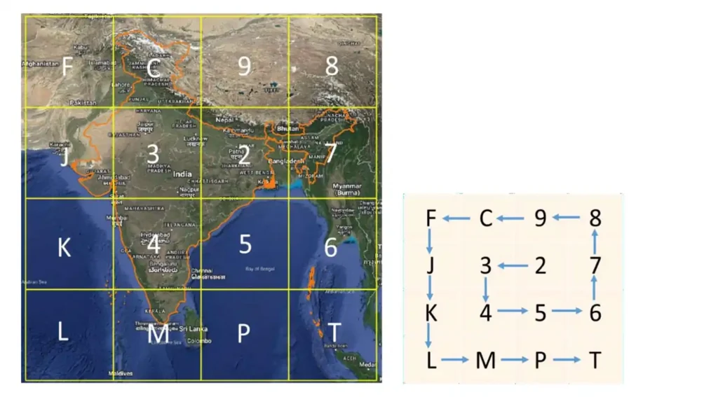
The system uses 16 specific symbols: the numbers 2 through 9 and the letters C, F, J, K, L, M, P, and T. These symbols were carefully chosen to avoid confusion when speaking or writing them. For instance, the number 1 and the letter I look too similar, so neither is used.
How DIGIPIN Creates a Complete Digital Map
DIGIPIN covers the entire geographical territory of India, including our maritime zones. This means even oil rigs in the ocean or future artificial islands can have their own DIGIPIN addresses. The system encompasses coordinates from longitude 63.5 to 99.5 degrees east and latitude 2.5 to 38.5 degrees north, ensuring every part of India that matters to us is included.
What makes this system truly remarkable is its hierarchical structure. Each level of the code represents a progressively smaller area. A single character represents an area of about 1,000 kilometers, while the full 10-character code narrows it down to just 3.8 meters. This means you can share location information at whatever level of precision you need.
Real-World Applications That Will Transform India
The impact of DIGIPIN extends far beyond just having better addresses. Emergency services will be able to reach accident victims or medical emergencies with unprecedented accuracy. When someone calls for help, they can simply share their DIGIPIN, and ambulances or fire services will know exactly where to go without wasting precious time searching.
E-commerce and delivery services will experience a revolution in efficiency. Instead of dealing with unclear addresses and failed deliveries, courier services can navigate directly to the exact spot where packages need to be delivered. This will be particularly transformative for rural areas where traditional addressing has always been challenging.
Banking and financial services will also benefit significantly. Know Your Customer processes will become more accurate and reliable when addresses can be verified digitally. Insurance companies will be able to assess risks more precisely when they know exact locations of properties.
The agriculture sector could see remarkable improvements as well. Farmers can now have precise digital addresses for their fields, making it easier to access government schemes, receive agricultural supplies, or get technical support. Weather services and agricultural advisories can be delivered with location-specific accuracy.
The Technology That Makes It Work
DIGIPIN operates as an open-source system, meaning the technology is freely available for anyone to use and improve. The Department of Posts has made the complete technical documentation and programming code available on GitHub, encouraging developers across India to build applications that use DIGIPIN.
The system works both online and offline, which is crucial for a country like India where internet connectivity may not always be reliable. You can generate or decode a DIGIPIN without needing an active internet connection, making it practical for use in remote areas.
The encoding process transforms latitude and longitude coordinates into the alphanumeric DIGIPIN code through a mathematical algorithm. This means that any location’s DIGIPIN can be calculated directly from its geographical coordinates, and vice versa. The system is designed to work with standard GPS technology available in smartphones, making it accessible to ordinary citizens.
Privacy and Security Considerations
One of DIGIPIN’s strongest features is its respect for privacy. The system only represents a geographical location and does not store any personal information about who lives there or what happens at that location. Your DIGIPIN is simply a coordinate reference, much like saying you live at a particular latitude and longitude.
This privacy-first approach means that sharing your DIGIPIN does not reveal any personal details about you, your family, or your activities. It is purely a location identifier that helps others find a place, nothing more.
Integration with India’s Digital Infrastructure
DIGIPIN aligns perfectly with India’s National Geospatial Policy 2022, which aims to strengthen our country’s spatial data infrastructure. The system integrates seamlessly with existing Geographic Information Systems and can enhance the accuracy of numerous digital services.
Government departments at the central, state, and local levels can now integrate DIGIPIN into their service delivery systems. This means more accurate implementation of welfare schemes, better urban planning, and improved disaster management capabilities.
The concept of “Address as a Service” that DIGIPIN enables means that any organization can build location-based services using this standardized addressing system. This could lead to innovations we have not yet imagined, as developers and entrepreneurs find new ways to use precise location data.
Continuous Improvement Through Public Participation
The Department of Posts has designed DIGIPIN as a living system that improves through public participation. Both the “Know Your DIGIPIN” and “Know Your PIN Code” portals include features for users to provide feedback on accuracy and suggest improvements.
This crowd-sourced approach to maintaining and improving the system ensures that DIGIPIN will become more accurate and useful over time. As more people use the system and provide feedback, any issues or inaccuracies can be quickly identified and corrected.
The Global Context of Digital Addressing
While several countries have developed their own digital addressing systems, DIGIPIN is uniquely designed for India’s specific geographical and cultural context. Unlike systems that work well in countries with regular street grids, DIGIPIN accommodates India’s diverse landscape, from dense urban areas to remote rural regions.
The system’s design philosophy recognizes that India needs an addressing solution that works for everyone, whether they live in a planned city or a traditional village. DIGIPIN provides this universal applicability while maintaining the precision needed for modern digital services.
Looking Toward the Future
DIGIPIN represents just the beginning of India’s transformation into a digitally connected nation where every citizen and location can be precisely identified and reached. As more services integrate DIGIPIN, we can expect to see improvements in everything from food delivery to disaster relief.
The open-source nature of DIGIPIN means that innovations and improvements will come not just from government agencies but from the entire technology community. Startups, established companies, and individual developers can all contribute to making the system better and finding new applications for precise location data.
Smart city initiatives across India will likely adopt DIGIPIN as a fundamental component of their infrastructure. Urban planning, traffic management, and municipal services will all benefit from having a standardized, precise addressing system.
Frequently Asked Questions
How do I find my DIGIPIN?
You can find your DIGIPIN by visiting the “Know Your DIGIPIN” portal at dac.indiapost.gov.in/mydigipin/home. Simply allow the website to access your location, or manually enter your latitude and longitude coordinates, and the system will generate your DIGIPIN immediately.
Will DIGIPIN replace traditional addresses?
DIGIPIN is designed to work alongside traditional addresses, not replace them entirely. Think of it as an additional, more precise way to identify locations that complements existing addressing systems. Many services will likely use both traditional addresses and DIGIPIN for maximum clarity.
Is there any cost to use DIGIPIN?
No, DIGIPIN is completely free to use. The Department of Posts has made it available as a public service, and the open-source nature means there are no licensing fees for businesses or developers who want to integrate it into their systems.
How accurate is DIGIPIN?
A complete 10-character DIGIPIN is accurate to within approximately 3.8 meters, which is more precise than most GPS systems available in consumer devices. For most practical purposes, this level of accuracy is more than sufficient.
Can DIGIPIN work without internet?
Yes, DIGIPIN can be generated and decoded without an internet connection. Once you have the algorithm or application, you can convert between coordinates and DIGIPIN codes offline, making it practical for use in areas with limited connectivity.
What happens if I move to a new address?
Unlike traditional addresses that belong to you, DIGIPIN belongs to the location itself. If you move, you will have a new DIGIPIN for your new location. The DIGIPIN for your old address remains the same and will be relevant for whoever moves there next.
How does DIGIPIN handle apartment buildings or multi-story structures?
DIGIPIN identifies ground-level geographical coordinates. For multi-story buildings, additional information like floor numbers or apartment numbers would still be needed alongside the DIGIPIN to identify specific units within the building.
Is my privacy protected when using DIGIPIN?
Yes, DIGIPIN only represents a geographical location and contains no personal information. Sharing your DIGIPIN is similar to sharing coordinates and does not reveal anything about who you are or what you do at that location.
The launch of DIGIPIN marks a significant milestone in India’s journey toward comprehensive digitalization. This innovative addressing system promises to solve long-standing challenges while opening up new possibilities for innovation and service delivery. As more Indians begin using DIGIPIN and more services integrate this technology, we can expect to see transformative improvements in how we navigate, deliver, and connect across our incredible country.
The success of DIGIPIN will ultimately depend on widespread adoption and continuous improvement through public participation. By embracing this new technology and providing feedback to make it better, every Indian can contribute to building a more connected and efficiently navigable nation for future generations.